
Standard listing photos show a buyer what the inside of a house looks like. An aerial photo shows them the lifestyle they’re buying into.
That’s the difference. You’re not just selling a room; you’re selling a home’s place in the world. This perspective isn’t a luxury anymore—it’s a powerful way to build value before a prospect even steps through the door.
Imagine you're listing a waterfront property. Ground-level shots can capture the dock and the view from the deck, sure. But only an aerial shot can truly convey the sheer expanse of the water, the length of the private shoreline, and how the home is perfectly positioned to catch the sunset.
It instantly transforms the property from a "house near water" to a "waterfront estate."
Creating Crucial Context and Appeal
Buyers make decisions based on more than just square footage. They want to know about the neighborhood, how close the parks are, and what the local vibe is. Aerial photography answers these questions visually and instantly.
- Neighborhood Vibe: Is the home tucked away on a quiet cul-de-sac or is it just a short walk from a bustling town center? An aerial view tells that story at a glance.
- Property Boundaries: For larger properties or homes with funky lot shapes, a top-down view clarifies exactly what the buyer is getting. It makes the usable land area a tangible asset.
- Proximity to Amenities: Showing—not just telling—how close a home is to a golf course, beach, or popular hiking trail adds a layer of value that's hard to put into words.
This context is everything. In fact, properties marketed with drone or aerial photography sell an average of 68% faster than listings without them. Why? Because buyers get a complete picture of the offering, which leads to more qualified interest and a much higher chance they’ll book a showing. You can dig deeper into drone photography's impact on real estate sales and pricing to see the data for yourself.
A great aerial shot frames the property as the hero of its environment. It doesn’t just sell the structure; it sells the location, the privacy, and the dream.
Think about a condo listing. The interior photos might make it seem small. But an aerial shot revealing it's just a two-minute walk from a vibrant marina and popular restaurants completely flips the script. This is the kind of visual storytelling that turns passive browsers into engaged buyers, often leading to quicker offers and a better final sale price.
Choosing Your Path: Fly Solo or Hire a Pro?
So, you're sold on using aerial photo real estate marketing. Smart move. Now you've hit your first big decision: do you become the pilot, or do you bring in a professional to handle the high-flying shots for you?
There’s no single right answer here. The best path really depends on your budget, how comfortable you are with the tech, and frankly, how much time you have to spare.
Going the do-it-yourself (DIY) route puts you in complete control. You can shoot a property whenever the light is perfect and go back for more shots without having to book and pay someone else. But let's be clear—the startup cost isn't just a drone. You're looking at proper training, getting your FAA Part 107 license, and sorting out liability insurance. You're not just a photographer; you're the pilot in command, and that comes with serious legal and safety responsibilities.
On the flip side, hiring a professional makes the whole thing incredibly simple. A good drone pilot already has the expensive gear, all the necessary licenses, and the insurance to fly commercially. They bring an expert eye for composition, knowing just how to capture a property's best angles from above. You get polished, ready-to-use photos delivered to your inbox without ever leaving your desk.
Comparing DIY Drone Photography vs Hiring a Professional
Your decision here directly impacts your budget, the quality of your images, and the consistency across your listings. To make it easier, let's break down the key differences.
For agents juggling just a handful of listings each year, the cost and learning curve of the DIY route probably don't add up. But if you're a high-volume agent or part of a busy team, that initial investment in gear and training could easily pay for itself over time.
This image really drives home why this effort is so worthwhile. It shows exactly how aerial photos guide a buyer from a passing glance to a signed contract.
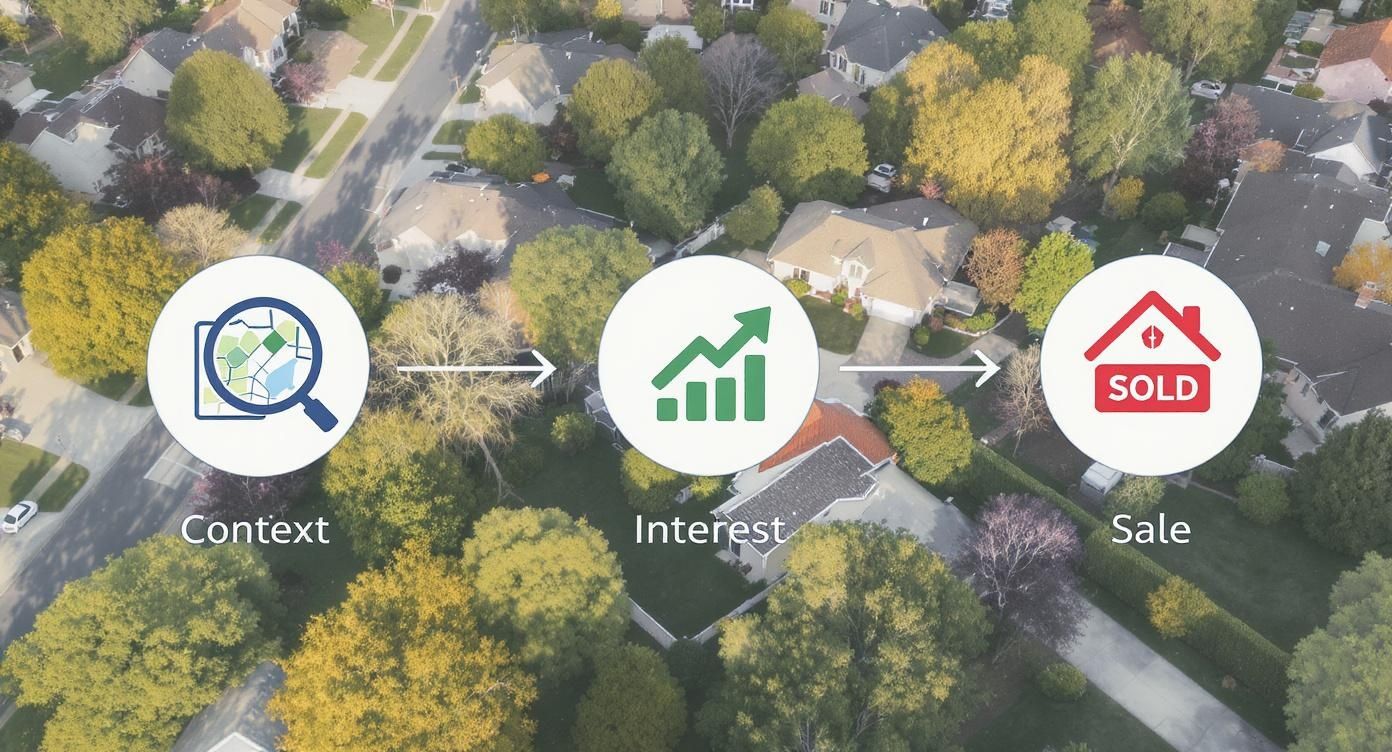
It all starts with context. When you show the whole neighborhood, the proximity to parks, and the layout of the land, you spark genuine interest that ground-level shots just can't match.
Breaking Down the Costs and Considerations
If you decide to hire a pro, you’ll find that pricing varies quite a bit depending on your market and what you need. As a rule of thumb, tacking aerial photos onto a standard real estate photography package usually runs between $50 and $250. For a much deeper dive, check out our guide on the cost for drone photography.
When you're vetting pilots, make sure you ask for these three things:
- Proof of their FAA Part 107 Certification. This is non-negotiable. It’s the law for anyone flying a drone for commercial purposes.
- Proof of liability insurance. You need to know they're covered in case something goes wrong.
- A strong portfolio. Look for examples that have the polished, professional style you want for your own listings.
Picking a pilot isn't about finding the cheapest option. It’s about finding a reliable partner who will consistently deliver stunning visuals that make your listings pop and get them sold faster.
In the end, whether you fly it yourself or hire an expert, the mission is the same: create powerful aerial images that tell the complete story of a property. Weigh the upfront investment, the time sink, and the legal hurdles to figure out which approach makes the most sense for your business.
Mastering Your Aerial Shot List and Composition
Getting a killer aerial photo for your listing isn’t about luck. It's about having a game plan. Whether you're flying the drone yourself or telling a pilot what you need, a solid shot list is your roadmap to getting every angle that tells the property's full story.
You need to think beyond just one high-altitude glamour shot. A truly effective set of aerials includes a mix of perspectives that show off the home, the lot, and the surrounding neighborhood. Your job is to guide the buyer's eye and build a narrative from the sky.
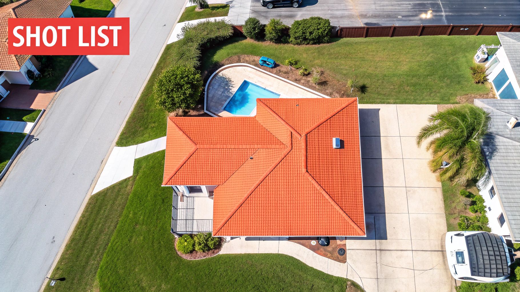
Your Essential Aerial Shot List
Every property is different, but starting with a go-to shot list gives you a solid foundation. The goal is to capture both the property's details and its place in the world.
Here are the perspectives you absolutely need to get:
- The Top-Down View: This is a straight-down, 90-degree overhead shot—think of it as a live, high-res map. It’s perfect for showing the full layout of the land, defining property lines, and highlighting features like pools, sport courts, or big patios.
- The Low Oblique Angle: Take this from a lower altitude at a 45-degree angle. It's a fantastic way to showcase the home's architecture and depth, giving it a more personal feel while still offering a view you can’t get from the street.
- The High Oblique Angle: This is your classic "hero shot." From up high, it captures the entire property and its immediate surroundings, showing buyers how the home sits in its environment. It’s the money shot for demonstrating scale and curb appeal from above.
- The Community & Amenity Shot: Now, pull back even further. Frame the property to include the nearby park, waterfront, golf course, or cool downtown strip. You’re not just selling a house; you’re selling a lifestyle.
This kind of strategic shooting has become the standard, especially in the luxury market. As drone tech has evolved, it has completely reshaped how high-end properties are marketed. Modern drones with 4K video and automated flight paths can create the kind of immersive digital tours that affluent buyers now expect. To learn more about where the market is headed, you can explore some of the current drone photography trends in luxury real estate.
Applying Composition Techniques from the Air
A good shot list gets you the right angles, but great composition is what makes those photos pop. The same rules you use for ground-level photography are just as critical when you're 300 feet up.
The best aerial photos use natural and man-made features to guide the viewer’s eye directly to the property, making it the undeniable star of the show.
For instance, use a long, winding driveway or a line of trees as leading lines that pull your gaze right to the front door. Frame the house using the rule of thirds by placing it slightly off-center—this creates a much more dynamic and interesting image.
These principles aren't just for drones. For a deeper dive, check out our guide on essential real estate photography tips that you can easily adapt for your aerial work.
Navigating the Legal Landscape of Drone Photography
So, you want to use aerial photo real estate marketing. Great choice. But the second you launch a drone to sell a property, you're not just a real estate agent anymore—you're an aircraft operator. The Federal Aviation Administration (FAA) takes that role very seriously, and you absolutely should too.
Trust me, ignoring the rules isn't worth the risk. The fines and legal headaches can dwarf any commission you hope to make.
The big one you need to know is the FAA's Small UAS Rule, better known as Part 107. If you're flying a drone for any commercial reason—and yes, that includes marketing a listing—you or your pilot must hold a Remote Pilot Certificate. This isn't a friendly suggestion; it's a federal mandate.
Getting certified means passing an official knowledge test. It covers everything from airspace classifications and weather patterns to the operational rules that keep everyone safe. It’s designed to ensure whoever is behind the controls knows what they’re doing.
Understanding Your Responsibilities
Getting your Part 107 license is just the first step. The sky might seem wide open, but it's actually a complex patchwork of local rules and regulations. This is where even well-intentioned agents can slip up.
You have to be mindful of several layers of authority:
- State and Local Laws: Many cities and counties have their own specific drone ordinances. These can dictate where you can fly, at what times, and how close you're allowed to get to private property.
- HOA Rules: Don't forget about Homeowners' Associations. They often have strict rules about drone use. Always check the community covenants before you even think about launching, or you could land your seller in hot water.
- Temporary Flight Restrictions (TFRs): The FAA issues TFRs for security reasons, like a presidential visit or a major sporting event. Flying into a TFR without authorization is a huge deal with serious consequences.
Think of it this way: Your Part 107 certificate is like your driver's license. It gives you permission to operate the vehicle, but you still have to obey every local speed limit and stop sign along the way. Compliance is an ongoing responsibility for every single flight.
Protecting Yourself from Liability
Even when you do everything right, things can go wrong. A sudden gust of wind, a lost signal, or a mechanical glitch could send a drone into someone’s roof or, in a worst-case scenario, injure a person. This is why drone liability insurance is non-negotiable.
Never, ever fly without it. And if you hire a pilot, make sure they’re covered. You’re looking for a policy with at least $1 million in liability coverage. This protects you, your client, and your brokerage from the financial nightmare of an accident. Always ask a pro for a copy of their insurance certificate before they start the job.
Privacy is the other big liability trap. Your goal is to showcase your listing, not your neighbor’s backyard. Be incredibly careful not to capture the neighbors sunbathing by their pool. Frame your shots to focus exclusively on your client's property. It’s about being a good neighbor and a responsible professional—two things that build trust and keep your business safe.
Weaving Your Aerial Shots Into Winning Marketing
Getting the perfect aerial photo is a great start, but it's not the finish line. Raw images straight from the drone are just your raw material. The real magic happens in post-production, where you turn those good shots into polished, compelling assets that stop buyers in their tracks.

Don't worry, this doesn't mean you need to become a Photoshop wizard overnight. Modern, user-friendly software like Adobe Lightroom or the built-in tools within Bounti can handle the essential tweaks that make all the difference. Your goal is simple: create bright, sharp, and true-to-life images that grab a buyer's attention and don't let go.
The Essential Photo Touch-Ups
Before you even think about uploading, run your aerial photos through a quick editing checklist. It's these small adjustments that separate amateur-hour from pro-level marketing.
- Color Correction: First, get the colors right. Adjust the white balance so the scene looks natural. Grass should be a vibrant green, not a sickly yellow, and a clear sky shouldn't have a weird gray or magenta cast.
- Exposure and Contrast: Brighten the image just enough to make it feel warm and inviting. A little boost in contrast will make the property's details pop, helping it stand out.
- Sharpening: A touch of sharpening can work wonders, bringing clarity to architectural lines, landscaping edges, and other key features. Just be careful—overdo it, and the image will look grainy and artificial.
- Strategic Cropping: Sometimes what you cut is as important as what you keep. Crop the photo to remove distracting elements at the edges and frame the property perfectly. Think "rule of thirds" here.
The point of editing isn’t to misrepresent a property; it's to present its absolute best self. It’s no different than professional staging—you’re simply highlighting the home’s most attractive features to make an unforgettable first impression.
Putting Your Aerials to Work
Once your images are polished and ready, it's time to deploy them everywhere. A killer aerial view should be one of the very first things a potential buyer sees.
Make that primary "hero shot"—the stunning high oblique angle we talked about—the featured image on the MLS. Right away, your listing will jump out from a sea of cookie-cutter, street-level photos. From there, use your other aerial shots to build a compelling visual story across all your marketing channels.
Here’s how that might look:
- On the Property Website: Create a dedicated gallery showcasing all your best aerials. Include the top-down view to clearly illustrate lot size and the community shot to highlight proximity to parks, schools, or the waterfront.
- For Social Media: Don't just post a static photo. Create a short video or an Instagram carousel that opens with a sweeping aerial view and then dives down to ground-level details. That dynamic movement is incredibly engaging.
- In Print Materials: For brochures, flyers, or mailers, a high-quality aerial photo on the cover creates an immediate "wow" factor that makes people want to see more.
This isn't just a gimmick; it's what the market demands. The demand for drone photography in real estate has skyrocketed by nearly 239% since 2021. Today, around 20% of all commercial drone flights are for property marketing. When you pair that demand with polished editing, you have a recipe for success.
And you don't have to stop there. Combining incredible aerials with tools like AI virtual staging, which can digitally furnish empty rooms, creates a truly irresistible package. To see how all these pieces fit together, check out our guide to modern property marketing.
Your Top Questions About Aerial Real-Estate Photography
Even once you're sold on the "why," a few practical questions always pop up before you dive into using drone photos for your listings. Let's get those sorted out so you can move forward and get those incredible shots.
What Is the Best Time of Day for Aerial Photos?
Hands down, the "golden hours" are your best friend here. This is the magic window—the first hour after sunrise and the last hour before sunset. The sun sits low in the sky, bathing the property in this incredible, soft, warm light.
This kind of light creates long, gentle shadows that give a home’s architecture and landscaping a real sense of depth and dimension. It just makes everything look more dramatic and appealing.
Trying to shoot midday is usually a mistake. The overhead sun is harsh, creating dark, ugly shadows and washing out colors. It makes even the most beautiful property look flat. If you absolutely can't swing a golden hour shoot, an overcast day is your next best bet. The clouds act like a giant light diffuser, giving you even, soft light to work with.
How Much Should I Expect to Pay?
Pricing for aerial photography definitely moves around depending on where you are and what you need, but there's a general ballpark to keep in mind.
When you bundle drone shots with your regular ground-level photo package, you're typically looking at an add-on cost between $50 and $250. This is almost always the most economical way to do it. If you're just hiring a pilot for a standalone aerial shoot, expect the price to be a bit higher. Always ask what's included—how many photos you get and what level of editing is covered.
Don't think of this as just another marketing expense. It’s an investment. The payoff comes from more eyes on your listing, a faster sale, and sometimes even stronger offers. It's a small price for a big impact.
What Kind of Turnaround Time Is Normal?
In a hot market, speed is everything. You can't be waiting around for photos. Luckily, most professional real estate photographers get this. You should expect to have your edited aerial photos back within 24 to 48 hours after the shoot.
This quick delivery means you can get your listing up on the MLS and push it out to all your marketing channels without missing a beat. Make sure you confirm the turnaround time with your photographer before you book them. A delay in visuals can stall your entire marketing plan.
How Many Aerial Photos Do I Really Need?
More is not better. You don't need a massive album of drone shots to impress buyers. It's all about quality over quantity.
For the vast majority of homes, a curated set of 5 to 10 high-quality aerial photos is perfect. That’s enough to tell the complete story without overwhelming potential buyers.
Your shot list should always include:
- The essential "hero shot" that frames the home beautifully within its lot.
- A top-down or "bird's-eye" view to show property lines and the yard's layout.
- A couple of angled shots from different sides to highlight cool architectural features.
- One wider context shot that shows off nearby perks, like a park, lake, or the coastline.
That’s it. This thoughtful selection gives a buyer all the visual information they need.
Ready to create stunning visuals for every listing, instantly? Bounti is your AI assistant for real estate. Go from a simple video walkthrough to a complete set of marketing materials—including MLS-ready photos, property descriptions, and even AI-powered virtual staging—in minutes. Learn more and get started with Bounti.ai.